
DeKalb ZIP Coverage by Postal Place
DeKalb's primary city mailing ZIP is 60115. Nearby 60112 belongs to Cortland postal geography, while 60178 belongs to Sycamore and appears on DeKalb County office addresses because Sycamore is the county seat. Census mapping shows ZCTA overlap around all three, but a ZCTA is a statistical area rather than a USPS delivery rule. The DeKalb ZIP code directory therefore treats 60112 and 60178 as nearby clues, not automatic proof of a DeKalb city address.
| ZIP | Areas Covered | Post Office | Notes |
|---|---|---|---|
| 60115 | Primary DeKalb city mailing area | DeKalb Post Office | Not identical to city limits |
| 60112 | Cortland postal area and nearby Census edge | Cortland postal place | Validate before calling it DeKalb city |
| 60178 | Sycamore postal area and county-seat offices | Sycamore postal place | County jurisdiction does not mean DeKalb city |
| Other result | Rural edge or source-specific place | As returned by USPS | Check the exact address and parcel |
The DeKalb Post Office is at 600 E Lincoln Highway, DeKalb, and the inspected USPS listing gives the 60115-3883 ZIP+4. It lists weekday service from 8:30 a.m. to 6:30 p.m., Saturday from 8:30 a.m. to 2:30 p.m., and 815-758-6677. Verify current hours before visiting.
A county name in a record is another frequent source of error. DeKalb County stretches well beyond DeKalb city and routes assessment questions through township assessors. The county seat is Sycamore. Thus, 60178 on a Clerk, Recorder, or court contact line identifies the office's mailing place, not the city associated with every deed, case, or certificate the office holds.
View the official DeKalb Post Office details.
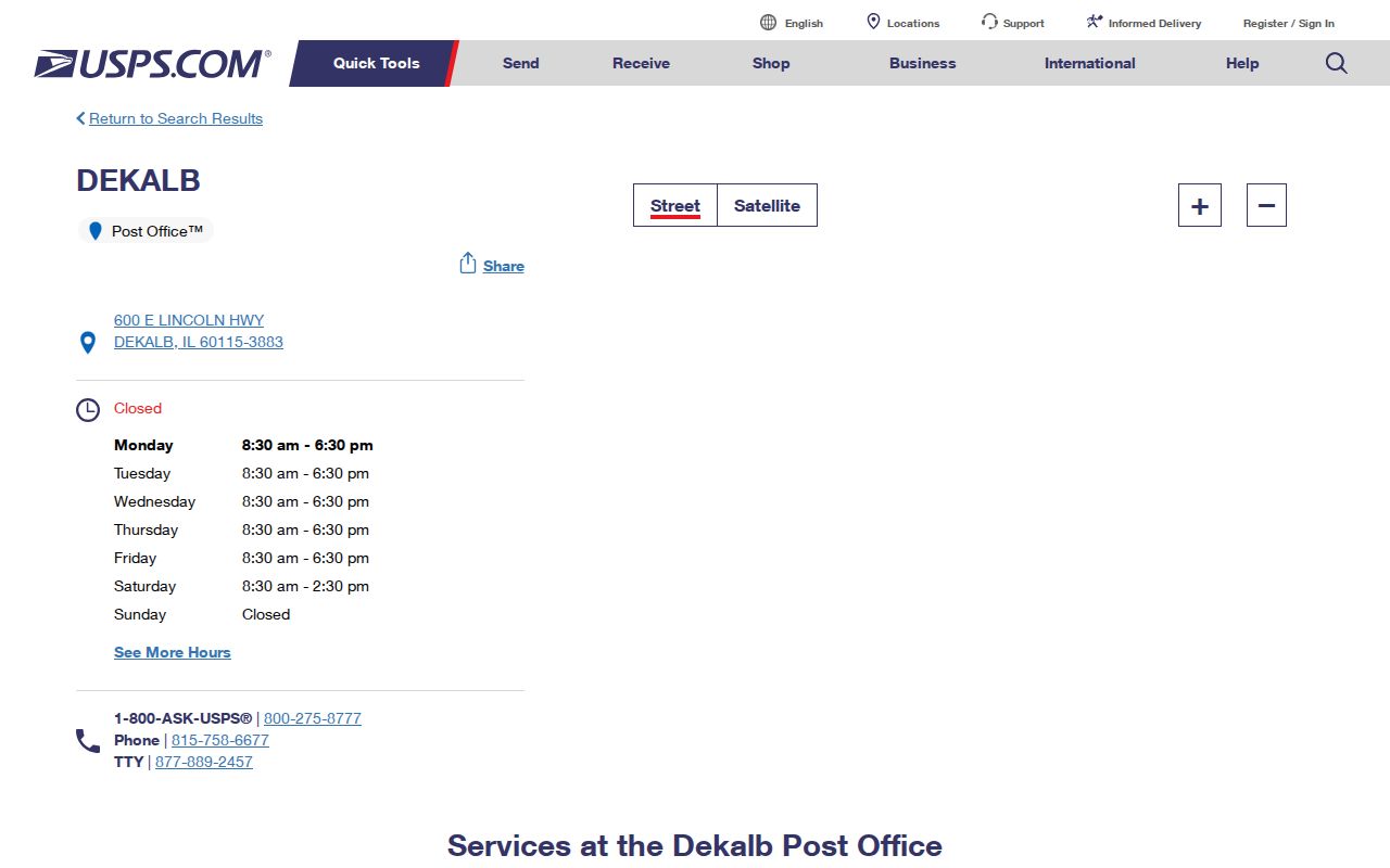
The source page ties the main postal station directly to 60115 and provides the current service contact.
DeKalb ZIP and Census Geography
USPS preferred city names and Census place names can differ. The Census explains that ZIP codes were made for mail delivery, while a city, county, township, tract, and ZIP Code Tabulation Area serve other geographic functions. That distinction matters in DeKalb, where a county office can have a Sycamore mailing address and still hold records for a DeKalb city parcel.
The Census city profile reports 40,290 people in the 2020 Census, a July 2024 estimate of 40,491, and a July 2025 estimate of 40,467. It reports 16.15 square miles of land and a 2020 density of 2,494.7 people per square mile. Those city figures should not be divided among 60112, 60115, and 60178 as if the ZCTA edges were city wards.
Read the Census explanation of USPS and Census geography.
The Census guidance shows why postal labels and legal city boundaries must be checked separately.
Search DeKalb Records by ZIP
Start with postal validation, then move to the county systems. The Recorder's LRS advanced index accepts a ZIP as an optional address field. The Illinois voter lookup requires a five-digit ZIP before it displays a street list. I-Cash accepts city and ZIP. Each result has a different meaning, so the ZIP code directory narrows a place but never turns all matching names into residents.
- Enter the complete street address in the USPS ZIP lookup.
- Record the returned city, state, five-digit code, ZIP+4, directional, and street suffix exactly.
- Use the normalized address and ZIP in the Recorder LRS. Compare the parcel or PIN when one appears.
- Check COMPASS or county GIS for parcel, township, ward, and municipal-boundary context.
- Preserve another postal city from an old directory or deed and search both variants instead of silently replacing it.
- For a county-seat result, keep Sycamore mailing geography separate from DeKalb County jurisdiction.
Once the search reaches a named road, the DeKalb street directory supplies the street-level parcel and deed workflow.
Note: The voter form's ZIP-generated street list is a registration control, not a public directory of all streets or residents.
DeKalb ZIP Search Fields
Several official forms accept postal information, but none offers a free-standing list of people by ZIP. USPS supports three modes: a street-address lookup, a city-and-state lookup, and a search for cities by ZIP. LRS combines ZIP with detailed land-record criteria. The voter form makes ZIP part of identity validation. Use the smallest set of fields that matches the task.
| Official source | ZIP control | Companion fields | Meaning of result |
|---|---|---|---|
| USPS | ZIP or ZIP+4 result | Street, city, state | Standard mail formatting |
| Recorder LRS | Optional ZIP | Address, city, parcel, names, dates | Indexed recorded instrument |
| Illinois voter lookup | Required five digits | Name, birth date, street number and name | Registration-status clue |
| I-Cash | ZIP narrowing field | Name, city, property ID | Unclaimed-property claim clue |
The county property route also includes COMPASS, GIS, and wEDGE. Township assessors remain the first stop for missing or disputed assessment detail. A PIN, meaning parcel identification number, may be a stronger county key than a mailing code because it points to the mapped tax parcel.
The Recorder index can combine ZIP with grantor or grantee name, address, city, parcel, subdivision, legal description, document criteria, and a date range. A grantor transfers an interest; a grantee receives one. Their indexed roles show a recorded transaction, not who currently gets mail. Printed portal documents are unofficial, so ask the Recorder at 815-895-7156 about an authenticated copy when the distinction matters.
DeKalb ZIPs Versus City Limits
A ZIP boundary and the DeKalb city line answer different questions. USPS organizes delivery. The city sets municipal jurisdiction. DeKalb County and its 19 townships provide still other layers across 632.7 square miles. A name tied to 60178 may concern a county office in Sycamore, while a Census ZCTA edge near 60112 does not relabel a Cortland mailing result as DeKalb city.
- ZIP code
- A USPS delivery geography represented by five digits.
- ZIP+4
- The five-digit code plus four digits that narrow a delivery segment.
- ZCTA
- A Census statistical approximation of ZIP geography, not the postal boundary itself.
- PO-box ZIP
- A code or use devoted to post-office boxes rather than ordinary street delivery.
- Unique ZIP
- A code assigned to one high-volume organization rather than a broad neighborhood.
- Carrier route
- A USPS delivery path within a postal area, not a city district.
Boundary check. Never infer DeKalb city jurisdiction from the postal city alone. Confirm the parcel in county GIS and the current municipal map.
DeKalb ZIP and Precinct Layers
Ward, precinct, polling-place, and ZIP maps are not interchangeable. County political-boundary GIS and City of DeKalb PDFs can explain which local election area covers a parcel, while the USPS result still controls delivery formatting. An older directory may use a ward or postal term that no longer matches the current map.
Open the official City of DeKalb precinct geography map.
The map provides a political layer to compare with the mailing code and parcel, without claiming that a precinct line is a ZIP boundary.
The statewide voter lookup uses ZIP only to load a street control. Released voter data has statutory restrictions and redactions, and it is not a general resident directory. For a record correction or current public-access question, contact DeKalb County Elections at 815-895-7147 or elections@dekalbcounty.org.
Historic DeKalb Postal Clues
Old DeKalb records may spell the place “De Kalb,” use a township, or identify a rural route rather than a current five-digit code. A city directory entry, deed, newspaper notice, or map should be preserved as printed. Searching only the modern postal form can hide a useful match.
No complete public road-name or house-number change register was located in the research. For a suspected change, ask County GIS or City Planning and Engineering for a bounded street, block, and period. Plats, ward maps, tax maps, and the seven-sheet 1891 De Kalb Sanborn set can help align an old intersection with the present parcel.
Annexation and subdivision changes can also move a site between city, township, ward, and postal labels without moving the building. The best check is a date-matched map plus the deed's legal description, not a modern ZIP alone.
County street guides, tax maps, ward maps, and political GIS can reveal whether a source's “DeKalb” label refers to the city, the county, or a nearby postal place. When none settles a road change, use the office counter, phone, or a focused Illinois Freedom of Information Act request. Ask for an existing map, addressing record, or replat within a clear year range instead of asking the agency to create a resident list.
DeKalb ZIP and Emergency Jurisdiction
DeKalb County's Emergency Telephone System Board was organized in the early 1990s and oversees enhanced 911 and around-the-clock public-safety answering points. That layer can help identify the correct agency for an address at a city or township edge. It is not a person directory and should not be used to infer occupancy.
For a public record tied to an edge address, first settle which agency created it. County and City of DeKalb requests have separate channels under the Illinois Freedom of Information Act. Describe the existing record, date range, address or parcel, and preferred delivery format. If the issue is only mail formatting, use USPS instead of a records request.
The DeKalb ZIP code directory is strongest as a sorting tool: postal result, parcel, municipal line, township, then the record custodian. Keeping those layers separate prevents a nearby Cortland or Sycamore clue from becoming a false claim about DeKalb residence.